Vaizdas:Pamir Highway Route.jpg

Šios peržiūros dydis: 592 × 600 taškų. Kitos 4 rezoliucijos: 237 × 240 taškų | 474 × 480 taškų | 758 × 768 taškų | 1 052 × 1 066 taškų.
Didesnės raiškos iliustracija (1 052 × 1 066 taškų, rinkmenos dydis: 200 KiB, MIME tipas: image/jpeg)
| Ši byla yra iš bendros Wikimedia Commons nemokamų resursų duomenų bazės, palaikomos Wikimedia Foundation organizacijos. Norėdami sužinoti licencijavimo smulkmenas, žiūrėkite paveikslėlio aprašymą |  |
Į paveikslėlio aprašymą |
| Aprašymas |
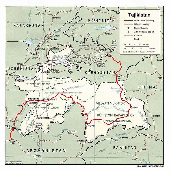
English: Map showing the route of the Pamir Highway through Afghanistan, Uzbekistan, Tajikistan, and Kyrgyzstan. |
| Data | |
| Šaltinis |
http://www.lib.utexas.edu/maps/tajikistan.html
|
| Autorius | Derived from CIA map by Bantman at en.wikipedia, transferred to Commons by User:Man77 using CommonsHelper. |
| Leidimas (Šios rinkmenos panaudojimas kitur) |
PD-USGOV; PD-AUTHOR. |
Licencija
This work is in the public domain in the United States because it is a work prepared by an officer or employee of the United States Government as part of that person’s official duties under the terms of Title 17, Chapter 1, Section 105 of the US Code.
Note: This only applies to original works of the Federal Government and not to the work of any individual U.S. state, territory, commonwealth, county, municipality, or any other subdivision. This template also does not apply to postage stamp designs published by the United States Postal Service since 1978. (See § 313.6(C)(1) of Compendium of U.S. Copyright Office Practices). It also does not apply to certain US coins; see The US Mint Terms of Use.
|
 | |
| This file has been identified as being free of known restrictions under copyright law, including all related and neighboring rights. | ||
| Šis darbas buvo paskelbtas viešajam naudojimui darbo autoriaus Bantman. Tai galioja visame pasaulyje. Kai kuriose šalyse tai negali būti legaliai leidžiama; jei taip: Bantman suteikia teisę naudoti šį darbą bet kokiai paskirčiai, be jokių sąlygų, nebent jos reikalaujamos įstatymų.
|
Originalus įkėlimo įrašas
Pirminis aprašymo puslapis buvo čia. Visi žemiau perteikti naudotojų vardai priklauso en.wikipedia.
- 2005-08-30 22:02 Bantman 1052×1066× (204866 bytes) Map showing the route of the Pamir Highway through Afghanistan, Tajikistan, and Kyrgyzstan. Derived by me from a CIA map located at the [[University_of_Texas_at_Austin#Facilities|Perry-Castañeda Library (PCL) of the University of Tex
Rinkmenos istorija
Paspauskite ant datos/laiko, kad pamatytumėte rinkmeną tokią, kokia ji buvo tuo metu.
| Data/Laikas | Miniatiūra | Matmenys | Naudotojas | Paaiškinimas | |
|---|---|---|---|---|---|
| dabartinis | 16:36, 11 balandžio 2009 | | 1 052 × 1 066 (200 KiB) | File Upload Bot (Magnus Manske) | {{BotMoveToCommons|en.wikipedia|year={{subst:CURRENTYEAR}}|month={{subst:CURRENTMONTHNAME}}|day={{subst:CURRENTDAY}}}} {{Information |Description={{en|Map showing the route of the en:Pamir Highway through en:Afghanistan, en:Tajikistan, |
Paveikslėlio naudojimas
Paveikslėlis yra naudojamas šiuose puslapiuose:
Visuotinis rinkmenos naudojimas
Ši rinkmena naudojama šiose viki svetainėse:
- Naudojama ca.wikipedia.org
- Naudojama cs.wikipedia.org
- Naudojama de.wikipedia.org
- Naudojama en.wikipedia.org
- Naudojama es.wikipedia.org
- Naudojama fa.wikipedia.org
- Naudojama fr.wikipedia.org
- Naudojama hu.wikipedia.org
- Naudojama it.wikipedia.org
- Naudojama ja.wikipedia.org
- Naudojama ko.wikipedia.org
- Naudojama lv.wikipedia.org
- Naudojama nl.wikipedia.org
- Naudojama pt.wikipedia.org
- Naudojama ru.wikipedia.org
- Naudojama sl.wikipedia.org
- Naudojama sv.wikipedia.org
- Naudojama uk.wikipedia.org
- Naudojama www.wikidata.org
- Naudojama zh.wikipedia.org