Vaizdas:Golan heights rel89B.jpg

Šios peržiūros dydis: 468 × 599 taškų. Kitos 3 rezoliucijos: 187 × 240 taškų | 375 × 480 taškų | 1 022 × 1 308 taškų.
Didesnės raiškos iliustracija (1 022 × 1 308 taškų, rinkmenos dydis: 231 KiB, MIME tipas: image/jpeg)
| Ši byla yra iš bendros Wikimedia Commons nemokamų resursų duomenų bazės, palaikomos Wikimedia Foundation organizacijos. Norėdami sužinoti licencijavimo smulkmenas, žiūrėkite paveikslėlio aprašymą |  |
Į paveikslėlio aprašymą |
Aprašymas
| Aprašymas |
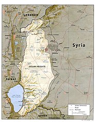
English: I created this image myself, by modifying the existing Image:Golan_heights_rel89A.jpg, which was itself a modified version of a modified CIA (and hence public domain) Image:Golan_92.jpg. Previous modifications were done to provide a map that was impartial about the contentious issue of which country owns the Golan Heights. The previous modifications were effective in creating a neutral map by removing the names "Syria" and "Israel" from the contentious territory and left only the label "Golan Heights". The present modification was intended solely to restore the names and locations of villages that were included on the original CIA map but had been (inadvertently) moved or erased by relocating the country titles. Due to the recurrent conflict involving villages and settlements within the Golan Heights, I feel that it is important to retain the locations on the map. As with the earlier modifications of this file, I hope that this modification will be seen as a fair compromise that also maintains the cartographical accuracy of map. I make no copyright claim on my modification; its copyright status is the same as its source. dp_roberson 15:44, 21 October 2007 (UTC) |
| Data | m. rugsėjo 21 d. (pirminio įkėlimo data) |
| Šaltinis | Perkelta iš en.wikipedia į Vikiteką. |
| Autorius | Dp roberson iš anglų kalbos Vikipedija |
Licencija
| Šis darbas buvo paskelbtas viešajam naudojimui darbo autoriaus Dp roberson iš anglų kalbos Vikipedija. Tai galioja visame pasaulyje. Kai kuriose šalyse tai negali būti legaliai leidžiama; jei taip: Dp roberson suteikia teisę naudoti šį darbą bet kokiai paskirčiai, be jokių sąlygų, nebent jos reikalaujamos įstatymų. |
Originalus įkėlimo įrašas
Pirminis aprašymo puslapis buvo čia. Visi žemiau perteikti naudotojų vardai priklauso en.wikipedia.
- 2008-12-29 03:13 كهيعص 1022×1308× (236080 bytes) added 4 villages to the map
- 2007-09-21 15:45 Dp roberson 1022×1308× (226330 bytes) I created this image myself, by modifying the existing Image:Golan_heights_rel89A.jpg, which was itself a modified version of a modified CIA (and hence public domain) Image:Golan_92.jpg. Previous modifications were done to provide a map that was impartia
Rinkmenos istorija
Paspauskite ant datos/laiko, kad pamatytumėte rinkmeną tokią, kokia ji buvo tuo metu.
| Data/Laikas | Miniatiūra | Matmenys | Naudotojas | Paaiškinimas | |
|---|---|---|---|---|---|
| dabartinis | 07:56, 27 sausio 2015 | | 1 022 × 1 308 (231 KiB) | Magog the Ogre | Reverted to version as of 22:56, 25 January 2015 |
| 01:56, 26 sausio 2015 |  | 468 × 599 (257 KiB) | OgreBot | (BOT): Reverting to most recent version before archival | |
| 01:56, 26 sausio 2015 |  | 1 022 × 1 308 (231 KiB) | OgreBot | (BOT): Uploading old version of file from en.wikipedia; originally uploaded on 2008-12-29 03:13:42 by كهيعص | |
| 16:20, 22 rugsėjo 2010 |  | 468 × 599 (257 KiB) | Ravpapa | Added the words "(Israeli occupied)" under the words "Golan Heights". This makes it clear that the area is occupied. | |
| 11:53, 5 kovo 2008 |  | 1 022 × 1 308 (221 KiB) | Cansado | {{Information |Description={{en|I created this image myself, by modifying the existing Image:Golan_heights_rel89A.jpg, which was itself a modified version of a modified CIA (and hence public domain) Image:Golan_92.jpg. Previous modifications were done to |
Paveikslėlio naudojimas
Paveikslėlis nenaudojamas nei viename straipsnyje.
Visuotinis rinkmenos naudojimas
Ši rinkmena naudojama šiose viki svetainėse:
- Naudojama ar.wikipedia.org
- Naudojama ba.wikipedia.org
- Naudojama de.wikinews.org
- Naudojama en.wikipedia.org
- Naudojama ru.wikipedia.org
- Naudojama tr.wikipedia.org