Vaizdas:Cat Island, Bahamas.JPG

Šios peržiūros dydis: 800 × 532 taškų. Kitos 6 rezoliucijos: 320 × 213 taškų | 640 × 426 taškų | 1 024 × 681 taškų | 1 280 × 852 taškų | 2 560 × 1 703 taškų | 4 256 × 2 832 taškų.
Didesnės raiškos iliustracija (4 256 × 2 832 taškų, rinkmenos dydis: 6,61 MiB, MIME tipas: image/jpeg)
| Ši byla yra iš bendros Wikimedia Commons nemokamų resursų duomenų bazės, palaikomos Wikimedia Foundation organizacijos. Norėdami sužinoti licencijavimo smulkmenas, žiūrėkite paveikslėlio aprašymą |  |
Į paveikslėlio aprašymą |
Aprašymas
| Aprašymas |
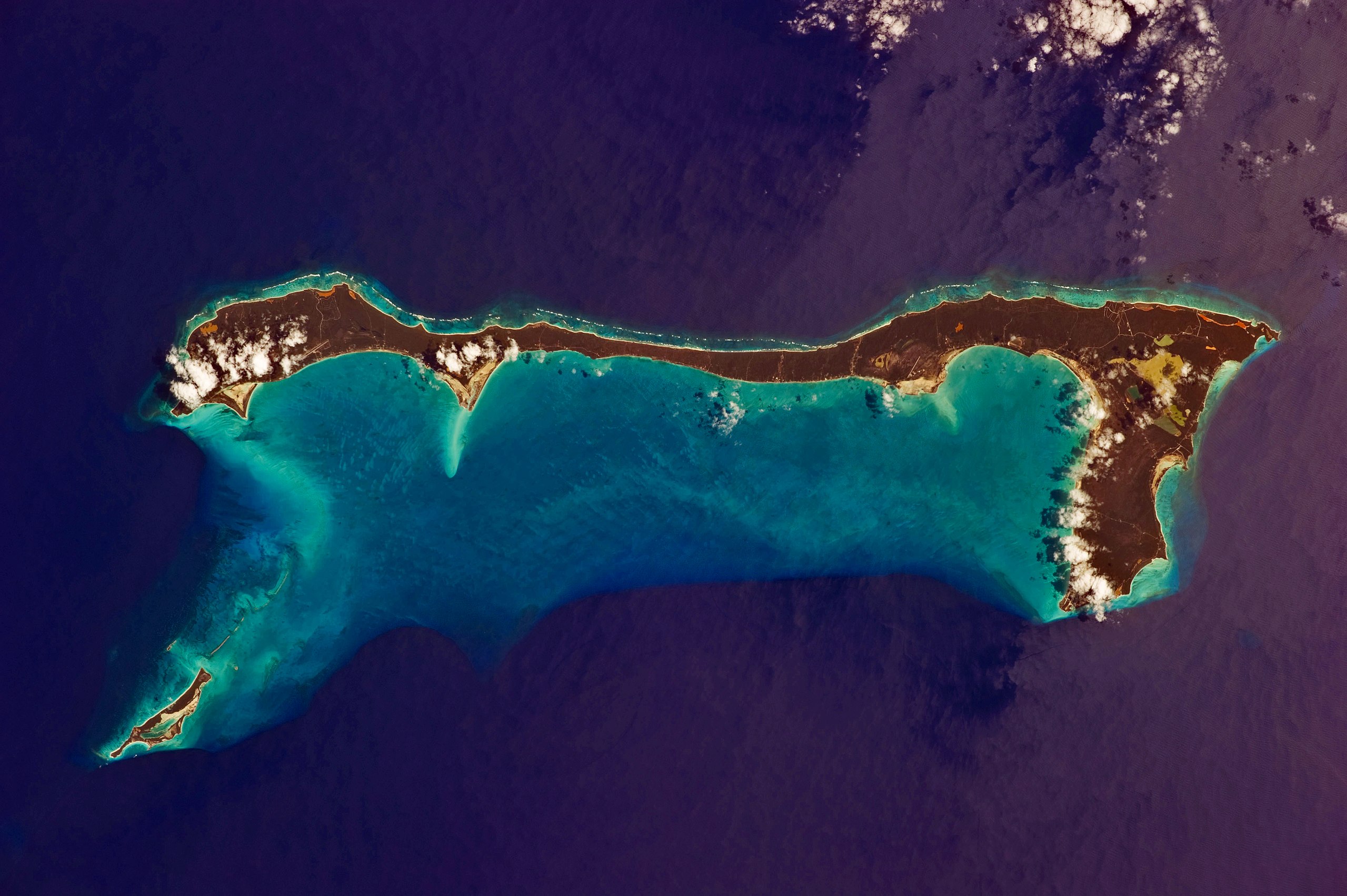
English: Like most other islands in the Bahamas, Cat Island is located on a large depositional platform that is composed mainly of carbonate sediments and surrounding reefs. The approximately 77 kilometre-long island is the part of the platform continuously exposed above water, which allows for soil development (brown to tan areas) and the growth of vegetation.
Shallow water to the west-south-west (below the island in this view) appears bright blue, in contrast to the deeper ocean waters to the north, east, and south. In this astronaut photograph, the ocean surface near the south-eastern half of the island has a slight grey tinge due to sun-glint, or light reflecting off the water surface back towards the International Space Station. Small white cumulus clouds obscure some parts of the island. |
| Data | |
| Šaltinis | NASA Earth Observatory |
| Autorius | ISS Expedition 26 crew |
| Fotografijos koordinatės | | Šis ir kiti paveikslėliai: OpenStreetMap |
|---|
This image or video was catalogued by Johnson Space Center of the United States National Aeronautics and Space Administration (NASA) under Photo ID: ISS026-E-33193. This tag does not indicate the copyright status of the attached work. A normal copyright tag is still required. See Commons:Licensing. Other languages:
|
Image acquired with a Nikon D3S digital camera using an effective 135 mm lens, and is provided by the ISS Crew Earth Observations experiment and Image Science & Analysis Laboratory, Johnson Space Center.
Licencija
| Šis failas licencijuojamas viešajam naudojimui, nes jis buvo sukurtas NASA. NASA autorinių teisių taisyklės nurodo, kad „NASA medžiaga nėra saugoma autorinių teisių, išskyrus pažymėtą“ (NASA autorių teisių taisylės arba JPL paveikslėlių naudojimo tvarka). | ||
 |
Įspėjimai:
|
| Annotations | This image is annotated: View the annotations at Commons |
Rinkmenos istorija
Paspauskite ant datos/laiko, kad pamatytumėte rinkmeną tokią, kokia ji buvo tuo metu.
| Data/Laikas | Miniatiūra | Matmenys | Naudotojas | Paaiškinimas | |
|---|---|---|---|---|---|
| dabartinis | 13:37, 21 kovo 2011 | | 4 256 × 2 832 (6,61 MiB) | Originalwana | {{Information |Description ={{en|1=Like most other islands in the Bahamas, Cat Island is located on a large depositional platform that is composed mainly of carbonate sediments and surrounding reefs. The approximately 77 kilometre-long island is the pa |
Paveikslėlio naudojimas
Paveikslėlis yra naudojamas šiuose puslapiuose:
Visuotinis rinkmenos naudojimas
Ši rinkmena naudojama šiose viki svetainėse:
- Naudojama ar.wikipedia.org
- Naudojama arz.wikipedia.org
- Naudojama az.wikipedia.org
- Naudojama ca.wikipedia.org
- Naudojama ceb.wikipedia.org
- Naudojama cs.wikipedia.org
- Naudojama de.wikipedia.org
- Naudojama de.wikivoyage.org
- Naudojama el.wikipedia.org
- Naudojama en.wikipedia.org
- Naudojama es.wikipedia.org
- Naudojama fi.wikipedia.org
- Naudojama fr.wikipedia.org
- Naudojama he.wikipedia.org
- Naudojama it.wikipedia.org
- Naudojama ko.wikipedia.org
- Naudojama nl.wikipedia.org
- Naudojama no.wikipedia.org
- Naudojama pl.wikipedia.org
- Naudojama pt.wikipedia.org
- Naudojama ro.wikipedia.org
- Naudojama www.wikidata.org
- Naudojama zh.wikipedia.org