Vaizdas:Abbasid Caliphate 891-892.png

Šios peržiūros dydis: 800 × 382 taškų. Kitos 5 rezoliucijos: 320 × 153 taškų | 640 × 306 taškų | 1 024 × 490 taškų | 1 280 × 612 taškų | 3 054 × 1 460 taškų.
Didesnės raiškos iliustracija (3 054 × 1 460 taškų, rinkmenos dydis: 1,44 MiB, MIME tipas: image/png)
| Ši byla yra iš bendros Wikimedia Commons nemokamų resursų duomenų bazės, palaikomos Wikimedia Foundation organizacijos. Norėdami sužinoti licencijavimo smulkmenas, žiūrėkite paveikslėlio aprašymą |  |
Į paveikslėlio aprašymą |
Aprašymas
| Aprašymas |
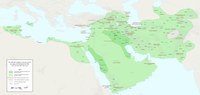
English: Map of the Abbasid Caliphate at the end of the reign of al-Mu'tamid in 891-892. Dark green denotes provinces under the effective control of the central government; light green denotes provinces under the control of autonomous governors or rebels.
The core Abbasid territories include Shahrazur, Darabadh, al-Samaghan, Hulwan, Masabadhan, Mihrijanqadhaq, the Euphrates districts, and Qarqisiyya (al-Tabari v. 37, p. 98; Bianquis p. 96). Map originally created as an .SVG file in Inkscape and converted to .PNG for size reasons. Background topography taken from DEMIS Mapserver, which are public domain. Works Cited:
|
| Data | |
| Šaltinis | Mano darbas |
| Autorius | Ro4444 |
| Kitos versijos |
 |
Licencija
Aš, šio darbo autoriaus teisių savininkas, publikuoju jį su šia licencija:
This file is licensed under the Creative Commons Attribution-Share Alike 4.0 International license.
- Jūs galite:
- dalintis – kopijuoti, platinti bei persiųsti šį darbą
- pri(si)taikyti – adaptuoti darbą
- Su šiomis sąlygomis:
- autoriaus nurodymas – Turite pateikti atitinkamą kreditą, pateikti nuorodą į licenciją ir nurodyti, ar buvo atlikti pakeitimai. Tai galite padaryti bet kokiu būdu, bet ne taip, kad licencijos išdavėjas patvirtintų jus ar jūsų naudojimą.
- dalinkis panašiai – Jei perdirbsite, redaguosite ar atkursite šį darbą, jį galėsite platinti tik su tokia pačia ar panašia į šią licencija.
Rinkmenos istorija
Paspauskite ant datos/laiko, kad pamatytumėte rinkmeną tokią, kokia ji buvo tuo metu.
| Data/Laikas | Miniatiūra | Matmenys | Naudotojas | Paaiškinimas | |
|---|---|---|---|---|---|
| dabartinis | 02:18, 4 gruodžio 2017 | | 3 054 × 1 460 (1,44 MiB) | Ro4444 | Further color corrections |
| 01:50, 4 gruodžio 2017 |  | 3 054 × 1 460 (1,44 MiB) | Ro4444 | Color correction | |
| 00:11, 4 gruodžio 2017 |  | 3 054 × 1 460 (1,44 MiB) | Ro4444 | User created page with UploadWizard |
Paveikslėlio naudojimas
Paveikslėlis nenaudojamas nei viename straipsnyje.
Visuotinis rinkmenos naudojimas
Ši rinkmena naudojama šiose viki svetainėse:
- Naudojama ar.wikipedia.org
- Naudojama de.wikiversity.org
- Naudojama en.wikipedia.org
- Naudojama en.wikibooks.org
- Naudojama et.wikipedia.org
- Naudojama fa.wikipedia.org
- Naudojama hy.wikipedia.org
- Naudojama id.wikipedia.org
- Naudojama ja.wikipedia.org
- Naudojama no.wikipedia.org
- Naudojama pt.wikipedia.org
- Naudojama sco.wikipedia.org
- Naudojama uk.wikipedia.org
- Naudojama uz.wikipedia.org
- Naudojama zh.wikipedia.org