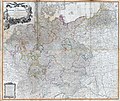
Vaizdas:1794 Delarochette Wall Map of the Empire of Germany - Geographicus - Germany-delarochette-1794.jpg

Didesnės raiškos iliustracija(8 000 × 7 128 taškų, rinkmenos dydis: 20,36 MiB, MIME tipas: image/jpeg)

Ši byla yra iš bendros Wikimedia Commons nemokamų resursų duomenų bazės, palaikomos Wikimedia Foundation organizacijos. Norėdami sužinoti licencijavimo smulkmenas, žiūrėkite paveikslėlio aprašymą
Paveikslėlio aprašymas
Į paveikslėlio aprašymą

Aprašymas

Warning The original file is very high-resolution. It might not load properly or could cause your browser to freeze when opened at full size.
Map of the Empire of Germany, Including All the States Comprehended under that Name: with the Kingdom of Prussia, &c.
Autorius
Pavadinimas
Map of the Empire of Germany, Including All the States Comprehended under that Name: with the Kingdom of Prussia, &c.
Aprašymas
English: An absolutely stunning and monumental two panel 1794 wall map of Germany, Bohemia, Austria and Prussia by Louis Stanislas d'Arcy Delarochette. Covers Germanic territories in full from the Baltic Sea to the Gulf of Venice. Includes Germany, Austria, Bohemia (Czech Republic), Poland, Lithuania, Prussia, Switzerland, Holland (the Netherlands), Belgium and Denmark. Offers an extraordinary level of detail throughout, noting roadways, towns, castles, monasteries, forests, swamps, rivers, cities and mountains. Even offers some offshore detail near Belgium and Holland. An elaborate allegorical title cartouche in the upper left quadrant depicts the German janiform eagle overlooking two warrior women and an assortment of military paraphernalia. Under it all, a baleful Medusa looks on. this is the 1794 updated edition of a map originally published in 1759. Published by Laurie and Whittle as plate nos. 18-19 in the 1797 edition of Thomas Kitchin's General Atlas .
Data 1794 m. (dated)
Matmenys aukštis: 42 in (106,6 cm); plotis: 48 in (121,9 cm)
dimensions QS:P2048,42U218593
dimensions QS:P2049,48U218593
Leidimo numeris
Geographicus link: Germany-delarochette-1794
Šaltinis/Fotografas

Kitchin, Thomas, Kitchin's General Atlas, describing the Whole Universe: being a complete collection of the most approved maps extant; corrected with the greatest care, and augmented from the last edition of D'Anville and Robert with many improvements by other eminent geographers, engraved on Sixty-Two plates, comprising Thirty Seven maps., Laurie & Whittle, London, 1797.

Kitos versijos

Licencija

Public domain

Šis failas yra viešo naudojimo tose šalyse, kuriose autorių teisės galiojimo netenka po 100 metų nuo autoriaus mirties.


Šis darbas laikomas viešo naudojimo Jungtinėse Amerikos Valstijose, nes jis buvo įregistruotas JAV Autorių Teisių Biure ar publikuotas iki 1929 m. sausio 1 d.

Captions

Add a one-line explanation of what this file represents

Items portrayed in this file

vaizduoja

media type anglų

image/jpeg

checksum anglų

660cfd2be177945653ef4bb05150f2172e403fc1

data size anglų

21 350 322 Baitas

7 128 pikselis

8 000 pikselis

Rinkmenos istorija

Paspauskite ant datos/laiko, kad pamatytumėte rinkmeną tokią, kokia ji buvo tuo metu.

Data/LaikasMiniatiūraMatmenysNaudotojasPaaiškinimas
dabartinis07:50, 23 kovo 2011Versijos 07:50, 23 kovo 2011 miniatiūra8 000 × 7 128 (20,36 MiB)BotMultichillT{{subst:User:Multichill/Geographicus |link=http://www.geographicus.com/P/AntiqueMap/Germany-delarochette-1794 |product_name=1794 Delarochette Wall Map of the Empire of Germany |map_title=Map of the Empire of Germany, Including All the States Comprehended

Paveikslėlis yra naudojamas šiuose puslapiuose:

Visuotinis rinkmenos naudojimas

Ši rinkmena naudojama šiose viki svetainėse: