Vaizdas:Winterwaroverview.JPG
Didesnės raiškos iliustracija (615 × 939 taškų, rinkmenos dydis: 139 KiB, MIME tipas: image/jpeg)
| Ši byla yra iš bendros Wikimedia Commons nemokamų resursų duomenų bazės, palaikomos Wikimedia Foundation organizacijos. Norėdami sužinoti licencijavimo smulkmenas, žiūrėkite paveikslėlio aprašymą |  |
Į paveikslėlio aprašymą |
Aprašymas
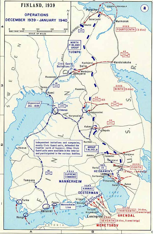
| Aprašymas | Map of the first phase of the Winter War 1939-40. |
| Data | Nežinoma data |
| Šaltinis | http://www.dean.usma.edu/history/web03/atlases/ww2%20europe/ww2%20europe%20pages/ww2%20europe%20map%2016.htm |
| Autorius | The Department of History at the U.S. Military Academy |
| Leidimas (Šios rinkmenos panaudojimas kitur) |
Public domain |
Background information:
In 1938 the predecessors of what is today The Department of History at the United States Military Academy began developing a series of campaign atlases to aid in teaching cadets a course entitled, "History of the Military Art." Since then, the Department has produced over six atlases and more than one thousand maps, encompassing not only America’s wars but global conflicts as well.
In keeping abreast with today's technology, the Department of History is providing these maps on the internet as part of the department's outreach program. The maps were created by the United States Military Academy’s Department of History and are the digital versions from the atlases printed by the United States Defense Printing Agency. We gratefully acknowledge the accomplishments of the department's former cartographer, Mr. Edward J. Krasnoborski, along with the works of our present cartographer, Mr. Frank Martini.
Please be aware that these maps are large in file size and may require substantial download times.
Licencija
Šis paveikslėlis yra JAV Armijos kareivio ar darbuotojo darbas, sukurtas asmeniui einant oficialias pareigas. Kaip JAV federalinės valdžios sukurtas darbas, paveikslėlis yra laikomas viešo naudojimo.
|
 |
Rinkmenos istorija
Paspauskite ant datos/laiko, kad pamatytumėte rinkmeną tokią, kokia ji buvo tuo metu.
| Data/Laikas | Miniatiūra | Matmenys | Naudotojas | Paaiškinimas | |
|---|---|---|---|---|---|
| dabartinis | 19:38, 1 spalio 2007 | | 615 × 939 (139 KiB) | Nasiruddin | *Description : Map of the first phase of the Winter War 1939-40 *Source: [http://www.dean.usma.edu/history/web03/atlases/ww2%20europe/ww2%20europe%20pages/ww2%20europe%20map%2016.htm *Background information: ''In 1938 the predecessors of what is today T |
Paveikslėlio naudojimas
Paveikslėlis yra naudojamas šiuose puslapiuose:
Visuotinis rinkmenos naudojimas
Ši rinkmena naudojama šiose viki svetainėse:
- Naudojama ar.wikipedia.org
- Naudojama bat-smg.wikipedia.org
- Naudojama de.wikipedia.org
- Naudojama en.wikipedia.org
- Naudojama es.wikipedia.org
- Naudojama et.wikipedia.org
- Naudojama fr.wikipedia.org
- Naudojama hr.wikipedia.org
- Naudojama ksh.wikipedia.org
- Naudojama lv.wikipedia.org
- Naudojama nn.wikipedia.org
- Naudojama no.wikipedia.org
- Naudojama ru.wikipedia.org
- Naudojama sq.wikipedia.org
- Naudojama uk.wikipedia.org