Vaizdas:SantoTomasdeCastilla.jpg

Šios peržiūros dydis: 597 × 599 taškų. Kitos 3 rezoliucijos: 239 × 240 taškų | 478 × 480 taškų | 863 × 866 taškų.
Didesnės raiškos iliustracija (863 × 866 taškų, rinkmenos dydis: 773 KiB, MIME tipas: image/jpeg)
| Ši byla yra iš bendros Wikimedia Commons nemokamų resursų duomenų bazės, palaikomos Wikimedia Foundation organizacijos. Norėdami sužinoti licencijavimo smulkmenas, žiūrėkite paveikslėlio aprašymą |  |
Į paveikslėlio aprašymą |
Aprašymas
| Aprašymas |
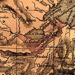
English: Fragment of "New Physical, Political, Industrial and Commercial Map of Central America and the Antilles: With a Special Map of the Possessions of the Belgian Colonization Company of Central America, the State of Guatemala" by N. Dally, 1845. |
||||||
| Data | |||||||
| Šaltinis | http://www.wdl.org/en/item/168/ | ||||||
| Autorius | N. Dally | ||||||
| Leidimas (Šios rinkmenos panaudojimas kitur) |
|
||||||
| Kitos versijos |
 |


Rinkmenos istorija
Paspauskite ant datos/laiko, kad pamatytumėte rinkmeną tokią, kokia ji buvo tuo metu.
| Data/Laikas | Miniatiūra | Matmenys | Naudotojas | Paaiškinimas | |
|---|---|---|---|---|---|
| dabartinis | 03:10, 23 rugsėjo 2014 | | 863 × 866 (773 KiB) | Nickpo | {{Information |description={{en|1=Fragment of "New Physical, Political, Industrial and Commercial Map of Central America and the Antilles: With a Special Map of the Possessions of the Belgian Colonization Company of Central America, the State of Guatem... |
Paveikslėlio naudojimas
Paveikslėlis yra naudojamas šiuose puslapiuose:
Visuotinis rinkmenos naudojimas
Ši rinkmena naudojama šiose viki svetainėse:
- Naudojama af.wikipedia.org
- Naudojama da.wikipedia.org
- Naudojama en.wikipedia.org
- Naudojama es.wikipedia.org
- Naudojama hy.wikipedia.org
- Naudojama ja.wikipedia.org
- Naudojama pt.wikipedia.org
- Naudojama ru.wikipedia.org