Vaizdas:Rzeczpospolita.png

Šios peržiūros dydis: 765 × 600 taškų. Kitos 5 rezoliucijos: 306 × 240 taškų | 612 × 480 taškų | 980 × 768 taškų | 1 280 × 1 004 taškų | 2 000 × 1 568 taškų.
Didesnės raiškos iliustracija (2 000 × 1 568 taškų, rinkmenos dydis: 332 KiB, MIME tipas: image/png)
| Ši byla yra iš bendros Wikimedia Commons nemokamų resursų duomenų bazės, palaikomos Wikimedia Foundation organizacijos. Norėdami sužinoti licencijavimo smulkmenas, žiūrėkite paveikslėlio aprašymą |  |
Į paveikslėlio aprašymą |
Aprašymas
| Aprašymas |
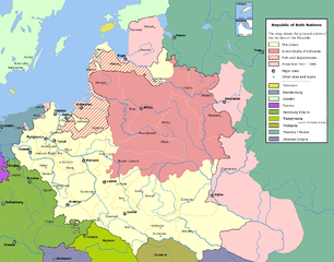
English: Commonwealth of Both Nations at the peak of its strength. The areas marked with light pink were lost to:
|
| Data | |
| Šaltinis | Mano darbas |
| Autorius | Halibutt |
| Leidimas (Šios rinkmenos panaudojimas kitur) |
GFDL, see below |
| Kitos versijos |
|

|
Šis paveikslėlis historical map (arba visos šio straipsnio iliustracijos) turėtų būti iš naujo sukurtas naudojant vektorinę grafiką, kaip, pavyzdžiui, SVG failas. To privalumus ir daugiau informacijos rasite straipsnyje Commons:Media for cleanup. Jei šio failo SVG versija jau sukurta, prašome ją įkelti. Po įkėlimo šios iliustracijos puslapyje pakeiskite šį šabloną į {{vector version available|naujas paveikslėlio pavadinimas.svg}}.
|
Licencija
Since the legal status of the above comment has been questioned, I hereby grant anyone the right to treat it as either a standard copyright notice, invariant section, legal statement, legal advice, friendly suggestion or a mere comment, depending on his or hers own choice. |
|

History of Poland
The following is a list of maps created by Halibutt and uploaded to commons, as well as their present and projected derivatives.
| Parent Image | Image | Description | |||||||||||
|---|---|---|---|---|---|---|---|---|---|---|---|---|---|
| Maps by Halibutt | |||||||||||||
| Image:Rzeczpospolita.png | Image:Rzeczpospolita.png | The Republic in 17th and 18th century | |||||||||||
| Image:Rzeczpospolita 1600.png | The Republic after the Treaty of Dywilino | ||||||||||||
| Image:Rzeczpospolita voivodships.png | Voivodships of The Republic | ||||||||||||
| Image:Rzeczpospolita_Potop.png | The Republic during The Deluge and Chmielnicki Uprising, with major battles of the era marked | ||||||||||||
| Magnates and their lands and domains | |||||||||||||
| 1st • 2nd • 3rd | Partitions of Poland | ||||||||||||
| War of the constitution | |||||||||||||
| Image:Rzeczpospolita.xcf | SOURCE FILE - GIMP format | ||||||||||||
| Image:Poland 1939.png | Image:Poland 1939.png | Poland in 1939 | |||||||||||
| Image:Dywizje wrzesien 1.png | Order of Battle on September 1st, during the Polish Defence War of 1939 | ||||||||||||
| Image:Poland 1939.xcf | SOURCE FILE - GIMP format | ||||||||||||
| Image:Polska kontur bialy.png | Image:Polska kontur bialy.png | Contour map of Poland AD 1999, for use with various locator maps | |||||||||||
| Image:Rzeczpospolita 1923.png | Image:Rzeczpospolita 1923.png | Map of Poland 1918-1939, currently under development | |||||||||||
| Image:PBW March 1919.png | Polish-Bolshevik War - fronts in March of 1919 | ||||||||||||
| Image:PBW December 1919.png | Polish-Bolshevik War - fronts in December of 1919 | ||||||||||||
| Image:PBW June 1920.png | Polish-Bolshevik War - fronts in July of 1920 | ||||||||||||
| Image:PBW August 1920.png | Polish-Bolshevik War - fronts in August of 1920 | ||||||||||||
| Polish Defence War of 1939 | |||||||||||||
| Polish areas annexed by Germany, Lithuania, Slovakia and the Soviet Union | |||||||||||||
| German concentration camps in Poland | |||||||||||||
| Curzon line | |||||||||||||
| Major battles of the Polish-Bolshevik War | |||||||||||||
| names • no names | Polish/Czechoslovak/Lithuanian/German/Ukrainian claims in 1920's | ||||||||||||
| Image:Rzeczpospolita Central Lithuania.png | Central Lithuania | ||||||||||||
| Image:Rzeczpospolita Lithuania claims.png | Central Lithuania as compared with other Lithuanian claims | ||||||||||||
| Image:Rzeczpospolita 1789-1920.png | Post-1922 borders compared with the territory of Poland before the partitions | ||||||||||||
| Warsaw Uprising and the Operation Tempest | |||||||||||||
| Poland partitioned between the Soviets and the Germans | |||||||||||||
| Image:Rzeczpospolita 1939 Polish divisions.png | Polish divisions on September 1, 1939 | ||||||||||||
| Home Army inspectorates | |||||||||||||
| Image:Rzeczpospolita 1922.xcf | SOURCE FILE - GIMP format | ||||||||||||
| Image:Rzeczpospolita 1937.svg | Vector version!!!! | layered version available on request | |||||||||||

|
This image (or all images in this category) uses inside labels or attached captions in a specific script or language and should be converted to a language neutral form. This would allow its use in all Wikimedia projects and, more importantly, all Wikimedia languages.
|
Rinkmenos istorija
Paspauskite ant datos/laiko, kad pamatytumėte rinkmeną tokią, kokia ji buvo tuo metu.
| Data/Laikas | Miniatiūra | Matmenys | Naudotojas | Paaiškinimas | |
|---|---|---|---|---|---|
| dabartinis | 17:37, 6 gegužės 2016 | | 2 000 × 1 568 (332 KiB) | Julieta39 | Cosmetic changes: see sources in the discussion page of today. |
| 13:40, 8 gruodžio 2009 |  | 2 000 × 1 568 (221 KiB) | Tryphon | Removed watermark. | |
| 22:34, 13 gruodžio 2004 |  | 2 000 × 1 568 (304 KiB) | Halibutt | Ok, final version at last (unless you have some more comments or suggestions) | |
| 10:47, 10 gruodžio 2004 |  | 2 000 × 1 568 (297 KiB) | Halibutt | final version? | |
| 04:36, 10 gruodžio 2004 |  | 2 000 × 1 568 (193 KiB) | Halibutt | new update | |
| 06:23, 8 gruodžio 2004 |  | 2 000 × 1 568 (141 KiB) | Halibutt | Commonwealth of Both Nations at the peak of its strength<br>Beta version of a map by Halibutt<br>{{User:Halibutt/GFDL}} |
Paveikslėlio naudojimas
Paveikslėlis yra naudojamas šiuose puslapiuose:
Visuotinis rinkmenos naudojimas
Ši rinkmena naudojama šiose viki svetainėse:
- Naudojama ar.wikipedia.org
- Naudojama arz.wikipedia.org
- Naudojama azb.wikipedia.org
- Naudojama bg.wikipedia.org
- Naudojama br.wikipedia.org
- Naudojama ca.wikipedia.org
- Naudojama da.wikipedia.org
- Naudojama de.wikipedia.org
- Naudojama de.wikibooks.org
- Naudojama en.wikipedia.org
- Naudojama eo.wikipedia.org
- Naudojama et.wikipedia.org
- Naudojama fi.wikipedia.org
- Naudojama fr.wikipedia.org
- Naudojama gl.wikipedia.org
- Naudojama hr.wikipedia.org
- Naudojama hsb.wikipedia.org
- Naudojama hu.wikipedia.org
- Naudojama id.wikipedia.org
- Naudojama it.wikipedia.org
- Naudojama ja.wikipedia.org
Žiūrėti visuotinį šios rinkmenos naudojimą.