Vaizdas:PIA00215-cropped.jpg
Šios peržiūros dydis: 766 × 599 taškų. Kitos 3 rezoliucijos: 307 × 240 taškų | 614 × 480 taškų | 869 × 680 taškų.
Didesnės raiškos iliustracija (869 × 680 taškų, rinkmenos dydis: 206 KiB, MIME tipas: image/jpeg)
| Ši byla yra iš bendros Wikimedia Commons nemokamų resursų duomenų bazės, palaikomos Wikimedia Foundation organizacijos. Norėdami sužinoti licencijavimo smulkmenas, žiūrėkite paveikslėlio aprašymą |  |
Į paveikslėlio aprašymą |
Aprašymas
| Aprašymas |
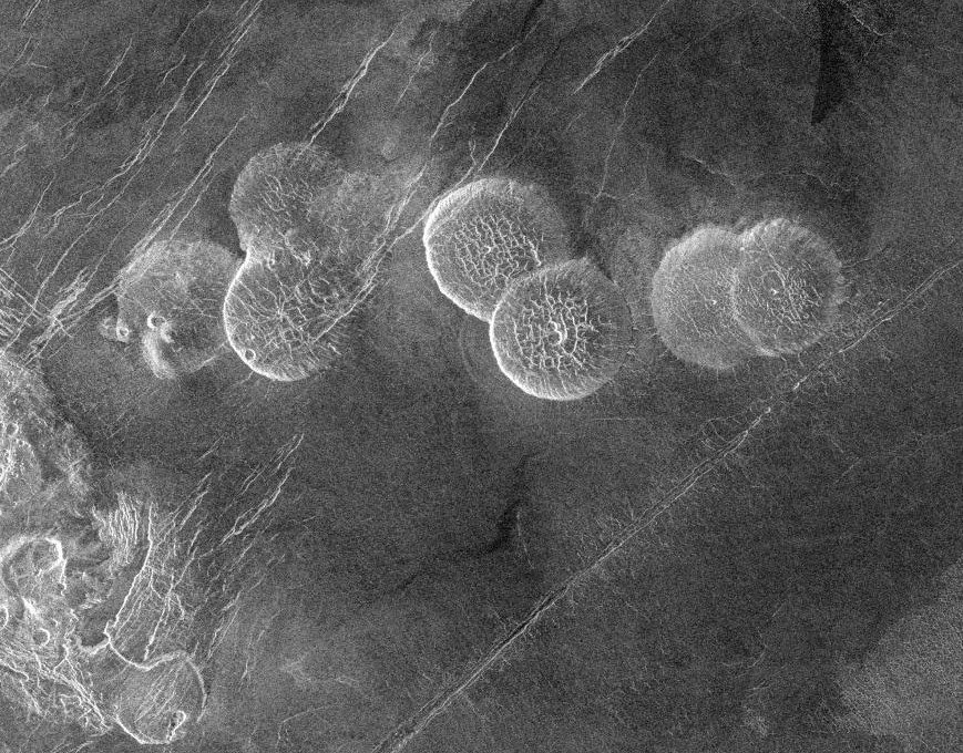
English: The eastern edge of Alpha Regio is shown in this image centered at 30 degrees south latitude and 11.8 degrees east longitude (longitude on Venus is measured from 0 degrees to 360 degrees east). Seven circular, dome-like hills, averaging 25 kilometers (15 miles) in diameter with maximum heights of 750 meters (2,475 feet) dominate the scene. These features are interpreted as very thick lava flows that came from an opening on the relatively level ground, which allowed the lava to flow in an even pattern outward from the opening. The complex fractures on top of the domes suggest that if the domes were created by lava flows, a cooled outer layer formed and then further lava flowing in the interior stretched the surface. The domes may be similar to volcanic domes on Earth. Another interpretation is that the domes are the result of molten rock or magma in the interior that pushed the surface layer upward. The near-surface magma then withdrew to deeper levels, causing the collapse and fracturing of the dome surface. The bright margins possibly indicate the presence of rock debris on the slopes of the domes. Some of the fractures on the plains cut through the domes, while others appear to be covered by the domes. This indicates that active processes pre date and post date the dome-like hills. The prominent black area in the northeast corner of the image is a data gap. North is at the top of the image. Mosaic of Magellan radar images. The domes are called Seoritsu Farra (a map) |
| Data | |
| Šaltinis | http://photojournal.jpl.nasa.gov/catalog/PIA00215 |
| Autorius | NASA/JPL |
| Kitos versijos | file:Alpha Regio.jpg |
This image or video was catalogued by Jet Propulsion Laboratory of the United States National Aeronautics and Space Administration (NASA) under Photo ID: PIA00215. This tag does not indicate the copyright status of the attached work. A normal copyright tag is still required. See Commons:Licensing. Other languages:
|
| Šis failas licencijuojamas viešajam naudojimui, nes jis buvo sukurtas NASA. NASA autorinių teisių taisyklės nurodo, kad „NASA medžiaga nėra saugoma autorinių teisių, išskyrus pažymėtą“ (NASA autorių teisių taisylės arba JPL paveikslėlių naudojimo tvarka). | ||
 |
Įspėjimai:
|
Rinkmenos istorija
Paspauskite ant datos/laiko, kad pamatytumėte rinkmeną tokią, kokia ji buvo tuo metu.
| Data/Laikas | Miniatiūra | Matmenys | Naudotojas | Paaiškinimas | |
|---|---|---|---|---|---|
| dabartinis | 22:20, 27 lapkričio 2005 | | 869 × 680 (206 KiB) | Dodo | PIA00215: Venus - Alpha Regio The eastern edge of Alpha Regio is shown in this image centered at 30 degrees south latitude and 11.8 degrees east longitude (longitude on Venus is measured from 0 degrees to 360 degrees east). Seven circular, dome-like hill |
Paveikslėlio naudojimas
Paveikslėlis yra naudojamas šiuose puslapiuose:
Visuotinis rinkmenos naudojimas
Ši rinkmena naudojama šiose viki svetainėse:
- Naudojama bat-smg.wikipedia.org
- Naudojama ca.wikipedia.org
- Naudojama de.wikipedia.org
- Naudojama en.wikipedia.org
- Naudojama es.wikipedia.org
- Naudojama eu.wikipedia.org
- Naudojama fr.wikipedia.org
- Naudojama ja.wikipedia.org
- Naudojama nds.wikipedia.org
- Naudojama nn.wikipedia.org
- Naudojama no.wikipedia.org
- Naudojama pt.wikipedia.org
- Naudojama sk.wikipedia.org
- Naudojama zh.wikipedia.org