Vaizdas:Map of CSA 4.png
Didesnės raiškos iliustracija (1 200 × 609 taškų, rinkmenos dydis: 421 KiB, MIME tipas: image/png)
| Ši byla yra iš bendros Wikimedia Commons nemokamų resursų duomenų bazės, palaikomos Wikimedia Foundation organizacijos. Norėdami sužinoti licencijavimo smulkmenas, žiūrėkite paveikslėlio aprašymą |  |
Į paveikslėlio aprašymą |

|
Šis paveikslėlis historical map (arba visos šio straipsnio iliustracijos) turėtų būti iš naujo sukurtas naudojant vektorinę grafiką, kaip, pavyzdžiui, SVG failas. To privalumus ir daugiau informacijos rasite straipsnyje Commons:Media for cleanup. Jei šio failo SVG versija jau sukurta, prašome ją įkelti. Po įkėlimo šios iliustracijos puslapyje pakeiskite šį šabloną į {{vector version available|naujas paveikslėlio pavadinimas.svg}}.
|
Aprašymas
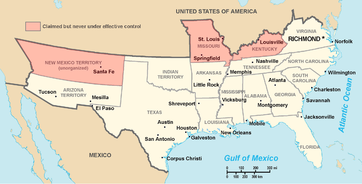
Historic Southern United States. The Confederate States have historically been regarded as forming "the South". States shown in light red are considered "border states", and gave varying degrees of support to the Southern cause although they remained in the Union. (This image depicts the original, trans-Allegheny borders of Virginia, and so does not show West Virginia separately. See the images above for post-1863 Virginia and West Virginia borders.) Although much of Indian Territory was aligned with the Confederacy, it had not yet been introduced into the Union as the state of Oklahoma. Drawn by Nicholas F Source en:wikipedia
Licencija
| |
Šis paveikslėlis (ar jo dalis) yra priskirtas viešajam naudojimui jo autoriaus, Nicholas F, , projekte Wikimedia Commons. Tai galioja visame pasaulyje. Atvejais, kai tai nėra teisiškai leistina: |
Rinkmenos istorija
Paspauskite ant datos/laiko, kad pamatytumėte rinkmeną tokią, kokia ji buvo tuo metu.
| Data/Laikas | Miniatiūra | Matmenys | Naudotojas | Paaiškinimas | |
|---|---|---|---|---|---|
| dabartinis | 02:22, 18 kovo 2006 | | 1 200 × 609 (421 KiB) | Fabrizio Fiorita~commonswiki | Drawn by Nicholas F Source en:wikipedia |
Paveikslėlio naudojimas
Paveikslėlis yra naudojamas šiuose puslapiuose:
Visuotinis rinkmenos naudojimas
Ši rinkmena naudojama šiose viki svetainėse:
- Naudojama af.wikipedia.org
- Naudojama ar.wikipedia.org
- Naudojama ca.wikipedia.org
- Naudojama de.wikipedia.org
- Naudojama en.wikipedia.org
- Naudojama eo.wikipedia.org
- Naudojama et.wikipedia.org
- Naudojama fi.wikipedia.org
- Naudojama frr.wikipedia.org
- Naudojama fy.wikipedia.org
- Naudojama gl.wikipedia.org
- Naudojama hu.wikipedia.org
- Naudojama hy.wikipedia.org
- Naudojama it.wikipedia.org
- Naudojama ja.wikipedia.org
- Naudojama la.wikipedia.org
- Naudojama lfn.wikipedia.org
- Naudojama lv.wikipedia.org
- Naudojama ms.wikipedia.org
- Naudojama nap.wikipedia.org
- Naudojama no.wikipedia.org
- Naudojama ro.wikipedia.org
- Naudojama ru.wikipedia.org
- Naudojama sl.wikipedia.org
- Naudojama sv.wikipedia.org
- Naudojama ta.wikipedia.org
- Naudojama tr.wikipedia.org
- Naudojama uk.wikipedia.org
- Naudojama vi.wikipedia.org
- Naudojama www.wikidata.org