Vaizdas:MSH82 lahar from march 82 eruption 03-21-82.jpg
Šios peržiūros dydis: 800 × 511 taškų. Kitos 5 rezoliucijos: 320 × 204 taškų | 640 × 409 taškų | 1 024 × 654 taškų | 1 280 × 818 taškų | 2 976 × 1 901 taškų.
Didesnės raiškos iliustracija (2 976 × 1 901 taškų, rinkmenos dydis: 1,54 MiB, MIME tipas: image/jpeg)
| Ši byla yra iš bendros Wikimedia Commons nemokamų resursų duomenų bazės, palaikomos Wikimedia Foundation organizacijos. Norėdami sužinoti licencijavimo smulkmenas, žiūrėkite paveikslėlio aprašymą |  |
Į paveikslėlio aprašymą |
Aprašymas
| Aprašymas |
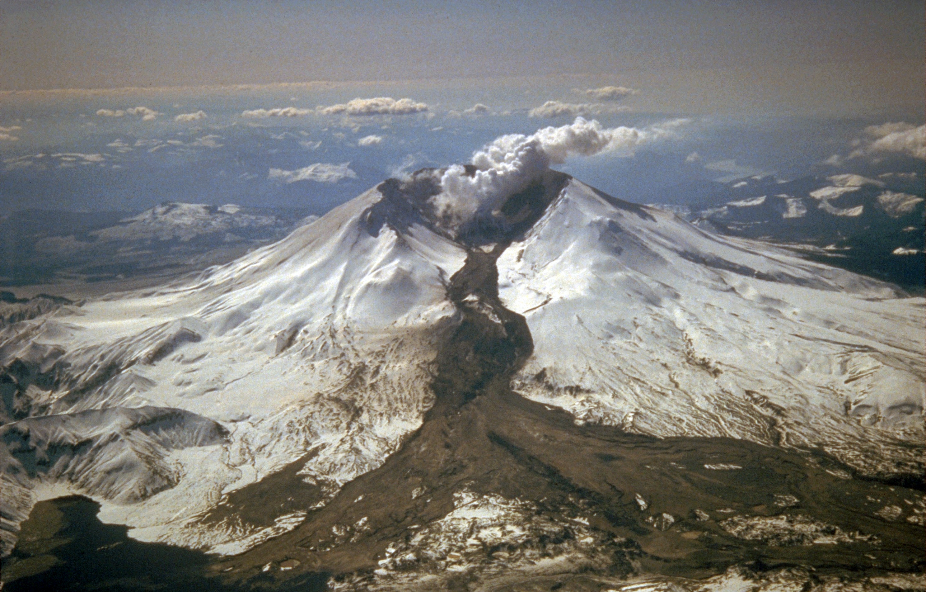
English: Mount St. Helens erupted often between 1980 and 1986. An explosive eruption on March 19, 1982, sent pumice and ash 9 miles (14 km) into the air, and resulted in a lahar (the dark deposit on the snow) flowing from the crater into the North Fork Toutle River valley. Part of the lahar entered Spirit Lake (lower left corner) but most of the flow went west down the Toutle River, eventually reaching the Cowlitz River, 50 miles (80 km) downstream. |
| Data | Taken on 1982 m. kovo 21 d. |
| Šaltinis | Archived source link, direct link |
| Autorius | Tom Casadevall, USGS |
Licencija
This image is in the public domain in the United States because it only contains materials that originally came from the United States Geological Survey, an agency of the United States Department of the Interior. For more information, see the official USGS copyright policy.
|
Rinkmenos istorija
Paspauskite ant datos/laiko, kad pamatytumėte rinkmeną tokią, kokia ji buvo tuo metu.
| Data/Laikas | Miniatiūra | Matmenys | Naudotojas | Paaiškinimas | |
|---|---|---|---|---|---|
| dabartinis | 14:07, 25 liepos 2011 | | 2 976 × 1 901 (1,54 MiB) | Aavindraa | remove fog |
| 09:14, 9 rugpjūčio 2005 |  | 2 976 × 1 901 (1,13 MiB) | Complex01 | USGS photo of Mt. Saint Helens. '''Caption''': Mount St. Helens erupted often between 1980 and 1986. An explosive eruption on March 19, 1982, sent pumice and ash 9 miles (14 kilometers) into the air, and resulted in a lahar (the dark deposit on the snow) |
Paveikslėlio naudojimas
Paveikslėlis yra naudojamas šiuose puslapiuose:
Visuotinis rinkmenos naudojimas
Ši rinkmena naudojama šiose viki svetainėse:
- Naudojama beta.wikiversity.org
- Naudojama be.wikipedia.org
- Naudojama bg.wikipedia.org
- Naudojama ca.wikipedia.org
- Naudojama cs.wikipedia.org
- Naudojama da.wikipedia.org
- Naudojama de.wikipedia.org
- Naudojama en.wikibooks.org
- Naudojama en.wikiversity.org
- Naudojama en.wiktionary.org
- Naudojama eo.wikipedia.org
- Naudojama es.wikipedia.org
- Naudojama et.wikipedia.org
- Naudojama fr.wikipedia.org
- Naudojama fr.wiktionary.org
- Naudojama gl.wikipedia.org
- Naudojama hu.wikipedia.org
- Naudojama it.wikipedia.org
- Naudojama it.wikibooks.org
- Naudojama it.wikiversity.org
- Naudojama ja.wikipedia.org
- Naudojama kk.wikipedia.org
- Naudojama nds.wikipedia.org
- Naudojama nl.wikipedia.org
- Naudojama oc.wikipedia.org
- Naudojama pl.wikipedia.org
- Naudojama pl.wiktionary.org
- Naudojama pt.wikipedia.org
- Naudojama ro.wikipedia.org
- Naudojama ru.wikipedia.org
Žiūrėti visuotinį šios rinkmenos naudojimą.