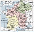
Vaizdas:Francia at the death of Pepin of Heristal, 714.jpg

Didesnės raiškos iliustracija(1 254 × 1 149 taškų, rinkmenos dydis: 1 MiB, MIME tipas: image/jpeg)

Ši byla yra iš bendros Wikimedia Commons nemokamų resursų duomenų bazės, palaikomos Wikimedia Foundation organizacijos. Norėdami sužinoti licencijavimo smulkmenas, žiūrėkite paveikslėlio aprašymą
Paveikslėlio aprašymas
Į paveikslėlio aprašymą

Aprašymas

Aprašymas
English: Francia at the death of Pepin of Heristal, 714
Français : Gaule à l'avènement de Charles Martel (714).
Data
Šaltinis Paul Vidal de la Blache's Atlas général d'histoire et de géographie (1912). The original scanned image can be found at http://www.hipkiss.org/data/maps/vidal-lablache_atlas-general-histoire-et-geographie_1912_ancient-gaul-merovian-merovingienne_2953_4252_600.jpg. Information on the original scan can be found at http://www.hipkiss.org/cgi-bin/maps.pl?book=Vidal%20Lablache%20-%20Atlas%20General%20Histoire%20Et%20Geographie.
Autorius
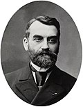
Paul Vidal de La Blache  (1845–1918)  wikidata:Q311865 s:fr:Auteur:Paul Vidal de La Blache q:fr:Paul Vidal de La Blache
 
Paul Vidal de La Blache
Kiti vardai
Paul Vidal de la Blanche
Aprašymas French geografas ir cartographer
Gimimo/mirties data 1845 m. sausio 22 d. Edit this at Wikidata 1918 m. balandžio 5 d. Edit this at Wikidata
Gimimo/mirties vieta Pézenas La Seyne-sur-Mer
Authority file
creator QS:P170,Q311865
Kitos versijos
Please translate the English parts of this template into Lithuanian.
Yra šio failo vektorinė versija (SVG formatu). Dėl geresnės kokybės ji turėtų būti naudojama vietoj šio rastrinio paveikslėlio.

File:Francia at the death of Pepin of Heristal, 714.jpg → File:Francia at the death of Pepin of Heristal 714-es.svg

Daugiau informacijos apie vektorinę grafiką rasite straipsnyje Commons perėjimas prie SVG.
Taip pat yra informacijos apie MediaWiki SVG formato palaikymą.

Kitomis kalbomis
Alemannisch  Bahasa Indonesia  Bahasa Melayu  British English  català  čeština  dansk  Deutsch  eesti  English  español  Esperanto  euskara  français  Frysk  galego  hrvatski  Ido  italiano  lietuvių  magyar  Nederlands  norsk bokmål  norsk nynorsk  occitan  Plattdüütsch  polski  português  português do Brasil  română  Scots  sicilianu  slovenčina  slovenščina  suomi  svenska  Tiếng Việt  Türkçe  vèneto  Ελληνικά  беларуская (тарашкевіца)  български  македонски  нохчийн  русский  српски / srpski  татарча/tatarça  українська  ქართული  հայերեն  বাংলা  தமிழ்  മലയാളം  ไทย  한국어  日本語  简体中文  繁體中文  עברית  العربية  فارسی  +/−
Naujas SVG paveikslėlis

Licencija

This image is in the public domain because it is a mere mechanical scan or photocopy of a public domain original, or – from the available evidence – is so similar to such a scan or photocopy that no copyright protection can be expected to arise. The original itself is in the public domain for the following reason:
Public domain

Šis failas yra viešo naudojimo tose šalyse, kuriose autorių teisės galiojimo netenka po 100 metų nuo autoriaus mirties.


Šis darbas laikomas viešo naudojimo Jungtinėse Amerikos Valstijose, nes jis buvo įregistruotas JAV Autorių Teisių Biure ar publikuotas iki 1929 m. sausio 1 d.


This tag is designed for use where there may be a need to assert that any enhancements (eg brightness, contrast, colour-matching, sharpening) are in themselves insufficiently creative to generate a new copyright. It can be used where it is unknown whether any enhancements have been made, as well as when the enhancements are clear but insufficient. For known raw unenhanced scans you can use an appropriate {{PD-old}} tag instead. For usage, see Commons:When to use the PD-scan tag.


Note: This tag applies to scans and photocopies only. For photographs of public domain originals taken from afar, {{PD-Art}} may be applicable. See Commons:When to use the PD-Art tag.

Originalus įkėlimo įrašas

The original description page is/was here. All following user names refer to en.wikipedia.

  • 2007-08-19 21:33 Srnec 1241×1136×8 (353954 bytes) The map comes from Vidal-Lablache, ''Atlas général d'histoire et de géographie'' (1894). {{PD-art-life-70}}
  • 2007-09-10 16:34 Earthsound 1254 × 1149×8 (1 MB) Gaule at the time of Charles Martel (714). The scale is 1:12,000,000 This is a straightened and color balanced crop of a scan of a map from Paul Vidal de la Blache's 'Atlas général d'histoire et de géograp. {{PD-art-life-70}}

Captions

Add a one-line explanation of what this file represents

Items portrayed in this file

vaizduoja

Rinkmenos istorija

Paspauskite ant datos/laiko, kad pamatytumėte rinkmeną tokią, kokia ji buvo tuo metu.

Data/LaikasMiniatiūraMatmenysNaudotojasPaaiškinimas
dabartinis17:26, 21 rugsėjo 2019Versijos 17:26, 21 rugsėjo 2019 miniatiūra1 254 × 1 149 (1 MiB)OgreBot(BOT): Reverting to most recent version before archival
17:26, 21 rugsėjo 2019Versijos 17:26, 21 rugsėjo 2019 miniatiūra1 241 × 1 148 (349 KiB)OgreBot(BOT): Uploading old version of file from en.wikipedia; originally uploaded on 2007-08-19 21:41:17 by Srnec
22:23, 22 sausio 2008Versijos 22:23, 22 sausio 2008 miniatiūra1 254 × 1 149 (1 MiB)Vladimir Solovjev{{Information |Description={{en|This is a straightened and color balanced crop of a scan of a map from Paul Vidal de la Blache's ''Atlas général d'histoire et de géographie'' (1912).}} |Source=Transfered from [http://en.wikipedia.org

Paveikslėlis yra naudojamas šiuose puslapiuose:

Visuotinis rinkmenos naudojimas