Didesnės raiškos iliustracija(1 894 × 1 367 taškų, rinkmenos dydis: 195 KiB, MIME tipas: image/png)

Ši byla yra iš bendros Wikimedia Commons nemokamų resursų duomenų bazės, palaikomos Wikimedia Foundation organizacijos. Norėdami sužinoti licencijavimo smulkmenas, žiūrėkite paveikslėlio aprašymą
Paveikslėlio aprašymas
Į paveikslėlio aprašymą
Šis paveikslėlis historical map (arba visos šio straipsnio iliustracijos) turėtų būti iš naujo sukurtas naudojant vektorinę grafiką, kaip, pavyzdžiui, SVG failas. To privalumus ir daugiau informacijos rasite straipsnyje Commons:Media for cleanup. Jei šio failo SVG versija jau sukurta, prašome ją įkelti. Po įkėlimo šios iliustracijos puslapyje pakeiskite šį šabloną į {{vector version available|naujas paveikslėlio pavadinimas.svg}}.

Aprašymas

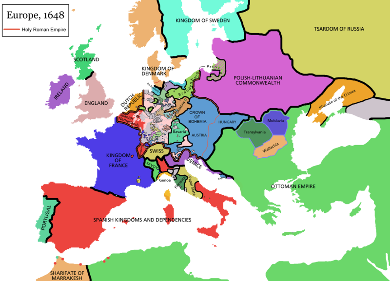
Map of Europe in 1648 (at the end of the Thirty Years War), based on free map of europe Image:BlankMap-Europe.png. Red line marks the border of the Holy Roman Empire. Information from Penguin atlas of modern history. (what year?)

Maps of the history of Europe
BCE
aC

Weichselian ice age (c. 113,000–9700) · Neolithic expansion (c. 7000–4500) · Middle Neolithic (c. 4500–4000) · Late Neolithic (c. 4000–3000) · Copper Age – Corded Ware culture (c. 2900–2350) · Copper Age – Bellbeaker culture (c. 2800–1800) · Early Bronze Age – Unetice culture (c. 2300–1600) · Late Bronze Age – Urnfield culture (c. 1300—750) · Migrations (c. 1000–100) · Hallstatt & La Tène cultures (c. 800–100) · Roman Republic (510–40) · 220 · 218 · 200 · 201–100 · 58 · 49 · 39 · 30 BCE–6 CE


CE
dC

14 · 14–37 · 60 · 60 · 69 · 80 · Migrations 100–500 · 117 · 117 · 125 · Migrations 150–774 · Economy 180 · 271 · 293–305 · 337 · 395 · c. 395 · 400 · 400 · 450 · 457–61 · 476 · 480 · Franks 481–814 · Early Slavs 500–700 · 500 · 526 · 526–600 · Christianisation to 600 · c. 550 · 650 · Pontic Steppe 650 · 665 · 800 · Vikings 800–1050 · 814 · 843–70 · 850 · 900 · 912 · 998 · 1000 · 1000 · 1054 · 1092 · First Crusade 1095–99 · 1097 · 1135 · 1142 · 1147–49 · 1190 · 1190 · 1250 · c. 1250 · 1301-1400 · 1301-1400 · 1328 · 1345 · Black Plague 1347–51 · 1360 · 1400 · Trade routes c. 1400 · 1430 · 1470 · 1490 · 1492 · 1500 · 1519 · 1550 · 1560 · Religion 1560 · Religion 1600 · Religion 1618 · 1618–48 · 1648 · 1683 · 1700 · 1701 · 1708 · 1714 · 1721 · 1725–30 · 1739–1740 · 1740 · 1748–66 · 1783–1792 · 1787 · 1787 · 1789 · 1799 · 1812 · 1812 · 1812 · 1812 · 1813 · 1815 · 1815 · 1815 · 1818 · Ottoman Empire 1830–1923 · 1848–49 · 1861 · 1867 · 1871 · 1878 · 1890 · 1905 · 1911 · 1914 · 1914 · 1919 · 1919–29 · 1923 · 1929 · 1930 · 1940 · 1941–42 · 1942–45 · Cold War 1947–91 · 1950 · 1993–2006 · 2006 to date

(this template: · view · discuss )


Licencija

GNU head Suteikiamas leidimas kopijuoti, platinti ir/ar redaguoti šį dokumentą pagal GNU Free Documentation licencijos versijos 1.2 ar bet kurios vėlesnės versijos sąlygas, publikuotas Free Software Foundation; be nekintamų dalių, be priekinių ir galinių tekstinių žymų viršeliuose. Šios licencijos kopija įtraukta dalyje, pavadintoje GNU Free Documentation License.
w:lt:Creative Commons
autoriaus nurodymas dalinkis panašiai
Šiam failui taikoma Creative Commons Attribution-Share Alike 3.0 Unported licencija.
Jūs galite:
  • dalintis – kopijuoti, platinti bei persiųsti šį darbą
  • pri(si)taikyti – adaptuoti darbą
Su šiomis sąlygomis:
  • autoriaus nurodymas – Turite pateikti atitinkamą kreditą, pateikti nuorodą į licenciją ir nurodyti, ar buvo atlikti pakeitimai. Tai galite padaryti bet kokiu būdu, bet ne taip, kad licencijos išdavėjas patvirtintų jus ar jūsų naudojimą.
  • dalinkis panašiai – Jei perdirbsite, redaguosite ar atkursite šį darbą, jį galėsite platinti tik su tokia pačia ar panašia į šią licencija.
Licencijos šablonas buvo priskirtas šiam failui kaip GFDL licencijos atnaujinimo dalis.

derivative works

Derivative works of this file:

Captions

Add a one-line explanation of what this file represents

Items portrayed in this file

vaizduoja

MIME type anglų

image/png

Rinkmenos istorija

Paspauskite ant datos/laiko, kad pamatytumėte rinkmeną tokią, kokia ji buvo tuo metu.

(Paskutiniai | Seniausi) Žiūrėti (10 naujesnių) () (10 | 20 | 50 | 100 | 250 | 500).
Data/LaikasMiniatiūraMatmenysNaudotojasPaaiškinimas
dabartinis12:44, 14 balandžio 2021Versijos 12:44, 14 balandžio 2021 miniatiūra1 894 × 1 367 (195 KiB)TenanReverted to version as of 16:09, 12 October 2017 (UTC) See discussion
13:47, 9 kovo 2021Versijos 13:47, 9 kovo 2021 miniatiūra1 894 × 1 367 (210 KiB)TTBCamhReverted to version as of 17:18, 20 September 2018 (UTC). I don't know why Raderich is saying this is an arbitrary change—Catalonia was under the possession of the French king in 1648, following the Catalan Revolt of 1640. This map is correct and the previous one is incorrect.
15:12, 25 rugsėjo 2018Versijos 15:12, 25 rugsėjo 2018 miniatiūra1 894 × 1 367 (195 KiB)RaderichReverted to version as of 21:15, 18 September 2018 (UTC) Undone arbitrary changes. Revert to correct map as uploaded by its creator Roke~commonswiki
20:18, 20 rugsėjo 2018Versijos 20:18, 20 rugsėjo 2018 miniatiūra1 894 × 1 367 (210 KiB)AmbroiseLThe Catalan counties were French since they proclaimed Louis XIV of France as their king. They wanted to be French in order not to obey the king of Spain anymore. Courland was a quite free vassal state of Poland. The reverted version doesn't show it. The reverted version also doesn't show the Venetian islands in the Adriatic Sea, and the Algerian towns that France occupied. Hence, I re-revert to the more precise version.
00:15, 19 rugsėjo 2018Versijos 00:15, 19 rugsėjo 2018 miniatiūra1 894 × 1 367 (195 KiB)RaderichReverted to version as of 16:09, 12 October 2017 (UTC)
13:45, 19 liepos 2018Versijos 13:45, 19 liepos 2018 miniatiūra1 894 × 1 367 (210 KiB)AmbroiseLReverted to version as of 12:06, 20 January 2017 (UTC) — reverted to the version with fixed names, my mistake
13:37, 19 liepos 2018Versijos 13:37, 19 liepos 2018 miniatiūra1 894 × 1 367 (150 KiB)AmbroiseLReverted to version as of 10:33, 24 September 2016 (UTC)
19:09, 12 spalio 2017Versijos 19:09, 12 spalio 2017 miniatiūra1 894 × 1 367 (195 KiB)Reverted to version as of 12:42, 9 September 2016 (UTC) why is Catalonia French? Not shown as such on File:Europe_1648_westphal_1884.jpg
15:06, 20 sausio 2017Versijos 15:06, 20 sausio 2017 miniatiūra1 894 × 1 367 (210 KiB)FakirbakirNames of Austria, Bohemia and Hungary are fixed.
13:33, 24 rugsėjo 2016Versijos 13:33, 24 rugsėjo 2016 miniatiūra1 894 × 1 367 (150 KiB)AmbroiseLAdjunction of polish-lithuanian vassal state of Courland
(Paskutiniai | Seniausi) Žiūrėti (10 naujesnių) () (10 | 20 | 50 | 100 | 250 | 500).

Paveikslėlis yra naudojamas šiuose puslapiuose:

Visuotinis rinkmenos naudojimas

Ši rinkmena naudojama šiose viki svetainėse:

Žiūrėti visuotinį šios rinkmenos naudojimą.

Meta duomenys