Vaizdas:Cyclone Catarina from the ISS on March 26 2004.JPG
Didesnės raiškos iliustracija(3 032 × 2 004 taškų, rinkmenos dydis: 1,01 MiB, MIME tipas: image/jpeg)

Ši byla yra iš bendros Wikimedia Commons nemokamų resursų duomenų bazės, palaikomos Wikimedia Foundation organizacijos. Norėdami sužinoti licencijavimo smulkmenas, žiūrėkite paveikslėlio aprašymą
Paveikslėlio aprašymas
Į paveikslėlio aprašymą
Vaizdas of the year
Vaizdas of the year
Dienos Vaizdas
Dienos Vaizdas
Former Featured picture

VikitekaVikipedija

Šis failas buvo kandidatu Metų Paveikslėlio Rinkimuose 2006-aisiais.
Šis paveikslėlis buvo tapęs dienos paveikslėliu 1--.
This formerly was a featured picture on Wikimedia Commons (Featured pictures) and was considered one of the finest images.
 Turėdamas kraštinių santykį lygų 8:5, 16:10 ar 16:9, šis paveikslėlis tinkamas naudoti plačiaekranių kompiuterių darbastaliuose (daugiau tokių paveikslėlių galite rasti galerijoje).

Vikipedija
 This is a featured picture on the arabų language Wikipedia (صور مختارة) and is considered one of the finest images.
 This formerly was a featured picture on the anglų language Wikipedia (Featured pictures) and was considered one of the finest images.
 This is a featured picture on the ispanų language Wikipedia (Recursos destacados) and is considered one of the finest images.
 This is a featured picture on the malajiečių language Wikipedia (Gambar pilihan) and is considered one of the finest images.
 This is a featured picture on the turkų language Wikipedia (Seçkin resimler) and is considered one of the finest images.

Jei turite panašios kokybės paveikslėlį, kuris gali būti publikuojamas tinkama autorinių teisių licencija, prašome jį įkelti, pažymėti tinkama licencija bei nominuoti.

Aprašymas
العربية: قبل سنة 2004م، سُجِّل ظُهور عاصفتين إستوائيتين فقط في حوض المُحيط الأطلسي الجنوبي، دون أن تظهر أيَّة أعاصير. على أنَّ إحدى العواصف الصغيرة التي ظهرت مُقابل شواطئ البرازيل الجنوبيَّة تطوَّرت حتَّى أصبحت لها خصائص العاصفة الاستوائيَّة واستمرَّت تتضخَّم مع توجُهها نحو الغرب. وسُرعان ما أصبح لِهذه العاصفة عينٌ مركزيَّة ووصلت قُوَّتها إلى قُوَّة الإعصار بِحسب الظاهر يوم الجُمُعة 26 آذار (مارس)، قبل أن يضرب اليابسة في أواخر يوم السبت 27 آذار (مارس) 2004م.
أُعلم طاقم محطَّة الفضاء الدوليَّة بِهذه العاصفة فالتقطوا لها صُورًا مُمتازة ما أن ضربت اليابسة في ولاية سانتا كاترينا بِجنوب البرازيل (بناءً على هذا أُطلق على العاصفة تسمية إعصار كاترينا). لاحظ كيف أنَّ حركة الأعاصير في النصف الجنوبي من الكُرة الأرضيَّة هي باتجاه عقارب. يُمكن رُؤية الساحل البرازيلي أسفل الغُيُوم في الزاوية العُليا اليُسرى من الصُورة.
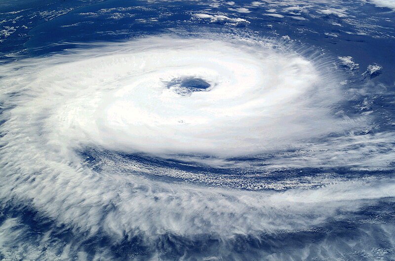
English: Before the year 2004, only two tropical cyclones had ever been noted in the South Atlantic Basin, and no hurricane. However, a circulation center well off the coast of southern Brazil developed tropical cyclone characteristics and continued to intensify as it moved westward. The system developed an eye and apparently reached hurricane strength on Friday, March 26, before eventually making landfall late on Saturday, March 27, 2004.
The crew of the International Space Station was notified of the cyclone and acquired excellent photographs of the storm just as it made landfall on the southern Brazilian state of Santa Catarina (the storm has been unofficially dubbed “Cyclone Catarina”). Note the clockwise circulation of Southern Hemisphere cyclones, the well-defined banding features, and the eyewall of at least a Category 1 system. The coastline is visible under the clouds in the upper left corner of the image.
Français : Avant 2004, aucun cyclone n'a jamais été observé dans l'Atlantique sud. Cependant, au cours du mois de mars 2004, un système dépressionnaire situé loin au large du Brésil a développé toutes les caractéristiques d'un ouragan tout en se déplaçant vers l'ouest. Le 26 mars, l'ouragan forme un œil bien défini ce qui correspond au niveau Cyclone. Le 27 mars 2007 au soir, il atteint les côtes brésiliennes.
L'équipe de la station spatiale internationale, informée du développement de ce cyclone inhabituel, a pu prendre de belles photos du cyclone juste au moment ou il a touché terre dans l'état brésilien de Santa Catarina (D’où son nom officieux de Cyclone Catarina. Le cyclone présente sur cette photo un œil bien défini, et tourne dans le sens des aiguilles d'une montre. La côte est visible en haut à gauche de l'image.
Data Taken on 2004 m. kovo 26 d.
Šaltinis

NASA

This is a retouched picture, which means that it has been digitally altered from its original version. Modifications: Increased contrast; decreased brightness; adjusted color balance in favor of blues and whites; removed large black splotches in several locations. Modifications made by Tomf688.

Autorius Astronaut photograph ISS008-E-19646 was taken March 7, 2004, with a Kodak DCS760 digital camera equipped with an 50-mm lens, and is provided by the Earth Observations Laboratory, Johnson Space Center.
Leidimas
(Šios rinkmenos panaudojimas kitur)
Public domain Šis failas licencijuojamas viešajam naudojimui, nes jis buvo sukurtas NASA. NASA autorinių teisių taisyklės nurodo, kad „NASA medžiaga nėra saugoma autorinių teisių, išskyrus pažymėtą (NASA autorių teisių taisylės arba JPL paveikslėlių naudojimo tvarka).
Įspėjimai:
This file was reviewed on 2011 m. gegužės 24 d. by the administrator or trusted user Jappalang (talk), who confirmed the Public Domain status on that date.
Kitos versijos

Derivative works of this file:

This image or video was catalogued by one of the centers of the United States National Aeronautics and Space Administration (NASA) under Photo ID: ISS008-E-19646.

This tag does not indicate the copyright status of the attached work. A normal copyright tag is still required. See Commons:Licensing.

Captions

Add a one-line explanation of what this file represents

Items portrayed in this file

vaizduoja

26 kovo 2004

MIME type anglų

image/jpeg

Rinkmenos istorija

Paspauskite ant datos/laiko, kad pamatytumėte rinkmeną tokią, kokia ji buvo tuo metu.

Data/LaikasMiniatiūraMatmenysNaudotojasPaaiškinimas
dabartinis03:56, 11 rugsėjo 2006Versijos 03:56, 11 rugsėjo 2006 miniatiūra3 032 × 2 004 (1,01 MiB)Tomhigher res
16:10, 8 rugsėjo 2005Versijos 16:10, 8 rugsėjo 2005 miniatiūra1 000 × 662 (321 KiB)Tom
09:27, 24 rugpjūčio 2005Versijos 09:27, 24 rugpjūčio 2005 miniatiūra1 000 × 662 (321 KiB)Tom{{PD-USGov-NASA}} http://eol.jsc.nasa.gov/sseop/images/EO/highres/ISS008/ISS008-E-19646.JPG Only two tropical cyclones had ever been noted in the South Atlantic Basin, and no hurricanes. However, a circulation center well off the coast of southern Brazi

Visuotinis rinkmenos naudojimas

Ši rinkmena naudojama šiose viki svetainėse:

Žiūrėti visuotinį šios rinkmenos naudojimą.

Meta duomenys