Vaizdas:Breakup of Yugoslavia.gif
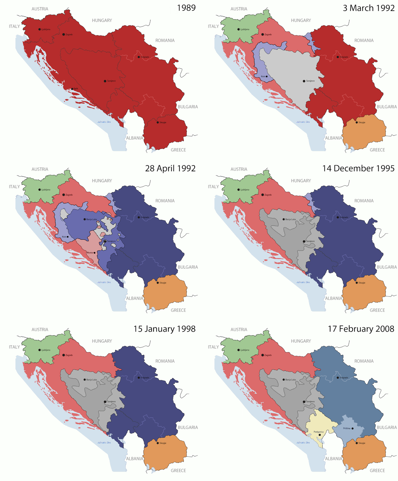
Didesnės raiškos iliustracija(1 545 × 1 242 taškų, rinkmenos dydis: 187 KiB, MIME tipas: image/gif, ciklinis, 14 kadrų, 44 s)

Ši byla yra iš bendros Wikimedia Commons nemokamų resursų duomenų bazės, palaikomos Wikimedia Foundation organizacijos. Norėdami sužinoti licencijavimo smulkmenas, žiūrėkite paveikslėlio aprašymą
Paveikslėlio aprašymas
Į paveikslėlio aprašymą
This image could be re-created using vector graphics as an SVG file. This has several advantages; see Commons:Media for cleanup for more information. If an SVG form of this image is available, please upload it and afterwards replace this template with {{vector version available|new image name}}. It is recommended to name the SVG file "Breakup of Yugoslavia.svg" - then the template Vector version available (or Vva) does not need the new image name parameter.

Aprašymas

Key:

Yugoslavia (1943–1992) SFR Yugoslavia
Croatia (1991–present) Croatia
Herzeg-Bosnia (1992–1994)
UNTAES (1996–1998)
Federal Republic of Yugoslavia / Serbia and Montenegro (1992–2006) Serbia and Montenegro
Republika Srpska (1992–present) Republika Srpska
Serbian Krajina (1991–1995/96)
Republic of Bosnia and Herzegovina (1992–1995)
Bosnia and Herzegovina (1998–present) Bosnia and Herzegovina
Western Bosnia (1993–1995)
Serbia (2006–present) Serbia
Kosovo (under UNMIK control 1999–present; declaration of independence 2008) Kosovo
Montenegro (2006–present) Montenegro
Macedonia (1991–present) Macedonia
Slovenia (1991–present) Slovenia


Aprašymas

This is an animated GIF that shows the stages of the breakup of the SFR Yugoslavia in the 90's and 2000's. The map based off Morwen's map of the divisions of the SFRY, Which is licensed by the GFDL. The source for the dates of independence is the CIA World Factbook. These maps do not now show the Inter-Entity Boundary Line (IEBL) and/or the entities that are separated by it. The IEBL has been drawn based on this CIA map; the Brčko District has been drawn based on Image:BH municipality location.gif, by user:Ante Perkovic. I might add them in the future.

Since the original map was GFDL, this image is as well.

A map depicting Kosovo's final status is ready once it takes effect.


Changelog for versions 2/3:

Here are some changes in this new build of the map:

  • The Kosovo boundary has been given a shade of red instead of the previous UN blue since they are a province of Serbia under UNIMIK control.
  • Montenegro's color has been changed to a golden shade close to what's on the flag.
  • The IEBL and the Brčko District has been redrawn because I deleted the original map; the color for the Republika Srpska is lighter.
  • The dates are at the top left hand corner of the map instead of the bottom.
  • I have taken a new approach as to the boundaries. Each part of Yugoslavia now shows the boundary on the maps starting the year they broke away. I feel this change helps readers understand the breakup better.
  • The SFRY and the FRY are in different shades since the FRY was never accepted as the successor to the former by the UN.
  • The colors for the entities of BiH have been removed as to not confuse people into thinking that they are independent states. What remains is the IEBL with both entities in green.
  • The Kosovo boundary is finally in hash marks!
  • The Brčko District has been removed. The sale is too small to show accurately.

Changelog for version 4:

  • The map is larger!
  • The image has been rebuilt to include the eastern part of FYR Macedonia.
  • The image has been updated to take in Kosovo's new status.
  • The IEBL is now a darker line.
  • Montenegro, Kosovo, and FRY/SCG/Serbia have new colors!

Changelog for version 5:

  • Rebuilt
  • Larger map: size of base image
  • Accurate Inter-Entity Boundary Line
Data 24 July 2006 (orginal upload date)
Šaltinis Made by Hoshie; see above for more details on sources.
Autorius Hoshie
Kitos versijos

Licencija

GNU head Suteikiamas leidimas kopijuoti, platinti ir/ar redaguoti šį dokumentą pagal GNU Free Documentation licencijos versijos 1.2 ar bet kurios vėlesnės versijos sąlygas, publikuotas Free Software Foundation; be nekintamų dalių, be priekinių ir galinių tekstinių žymų viršeliuose. Šios licencijos kopija įtraukta dalyje, pavadintoje GNU Free Documentation License.
w:lt:Creative Commons
autoriaus nurodymas dalinkis panašiai
Šiam failui taikoma Creative Commons Attribution-Share Alike 3.0 Unported licencija.
Jūs galite:
  • dalintis – kopijuoti, platinti bei persiųsti šį darbą
  • pri(si)taikyti – adaptuoti darbą
Su šiomis sąlygomis:
  • autoriaus nurodymas – Turite pateikti atitinkamą kreditą, pateikti nuorodą į licenciją ir nurodyti, ar buvo atlikti pakeitimai. Tai galite padaryti bet kokiu būdu, bet ne taip, kad licencijos išdavėjas patvirtintų jus ar jūsų naudojimą.
  • dalinkis panašiai – Jei perdirbsite, redaguosite ar atkursite šį darbą, jį galėsite platinti tik su tokia pačia ar panašia į šią licencija.
Licencijos šablonas buvo priskirtas šiam failui kaip GFDL licencijos atnaujinimo dalis.

Captions

Add a one-line explanation of what this file represents

Items portrayed in this file

vaizduoja

MIME type anglų

image/gif

checksum anglų

05ca2aefea8406b809968643552d5095c847a42f

data size anglų

191 625 Baitas

44 sekundė

1 242 pikselis

1 545 pikselis

Rinkmenos istorija

Paspauskite ant datos/laiko, kad pamatytumėte rinkmeną tokią, kokia ji buvo tuo metu.

(Paskutiniai | Seniausi) Žiūrėti (10 naujesnių) () (10 | 20 | 50 | 100 | 250 | 500).
Data/LaikasMiniatiūraMatmenysNaudotojasPaaiškinimas
dabartinis10:40, 17 liepos 2016Versijos 10:40, 17 liepos 2016 miniatiūra1 545 × 1 242 (187 KiB)מפתח-רשימהReverted to version as of 17:22, 21 August 2015 (UTC)
20:22, 21 rugpjūčio 2015Versijos 20:22, 21 rugpjūčio 2015 miniatiūra1 463 × 1 158 (1,81 MiB)BraganzaReverted to version as of 03:57, 19 January 2010
20:22, 21 rugpjūčio 2015Versijos 20:22, 21 rugpjūčio 2015 miniatiūra1 545 × 1 242 (187 KiB)BraganzaReverted to version as of 01:02, 19 December 2011
20:15, 21 rugpjūčio 2015Versijos 20:15, 21 rugpjūčio 2015 miniatiūra120 × 95 (3 KiB)Braganza03:57, 19. Jan. 2010
04:02, 19 gruodžio 2011Versijos 04:02, 19 gruodžio 2011 miniatiūra1 545 × 1 242 (187 KiB)DIREKTORAdded details
21:09, 27 liepos 2011Versijos 21:09, 27 liepos 2011 miniatiūra1 545 × 1 242 (170 KiB)DIREKTORSmall fixes
20:28, 27 liepos 2011Versijos 20:28, 27 liepos 2011 miniatiūra1 545 × 1 242 (171 KiB)DIREKTORAdded UNMIK
19:38, 27 liepos 2011Versijos 19:38, 27 liepos 2011 miniatiūra1 545 × 1 242 (165 KiB)DIREKTORDates for the last two frames.
15:10, 27 liepos 2011Versijos 15:10, 27 liepos 2011 miniatiūra1 545 × 1 242 (149 KiB)DIREKTORLighter shade for country names
19:59, 26 liepos 2011Versijos 19:59, 26 liepos 2011 miniatiūra1 545 × 1 242 (170 KiB)DIREKTORHigher res plus details
(Paskutiniai | Seniausi) Žiūrėti (10 naujesnių) () (10 | 20 | 50 | 100 | 250 | 500).

Visuotinis rinkmenos naudojimas

Ši rinkmena naudojama šiose viki svetainėse:

Žiūrėti visuotinį šios rinkmenos naudojimą.

Meta duomenys