Vaizdas:Bay of Campeche.jpg
Nėra didesnės raiškos varianto.
Bay_of_Campeche.jpg (384 × 185 taškų, rinkmenos dydis: 26 KiB, MIME tipas: image/jpeg)
| Ši byla yra iš bendros Wikimedia Commons nemokamų resursų duomenų bazės, palaikomos Wikimedia Foundation organizacijos. Norėdami sužinoti licencijavimo smulkmenas, žiūrėkite paveikslėlio aprašymą |  |
Į paveikslėlio aprašymą |
Aprašymas

|
Šis paveikslėlis locator map (arba visos šio straipsnio iliustracijos) turėtų būti iš naujo sukurtas naudojant vektorinę grafiką, kaip, pavyzdžiui, SVG failas. To privalumus ir daugiau informacijos rasite straipsnyje Commons:Media for cleanup. Jei šio failo SVG versija jau sukurta, prašome ją įkelti. Po įkėlimo šios iliustracijos puslapyje pakeiskite šį šabloną į {{vector version available|naujas paveikslėlio pavadinimas.svg}}.
|


| Aprašymas |
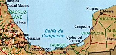
English: Bay of Campeche (On this map, as in some other, often confused with the smaller Bahía de Campeche). Map of the Bay of Campeche, scene of most of the exploits of the Austin.
עברית: מפרץ קמפצ'ה.
日本語: カンペチェ湾.
ქართული: კამპეჩეს ყურის რუკა.
Lietuvių: Kampečės įlanka.
Português: A baía de Campeche.
Русский: Карта залива Кампече.
Simple English: Bay of Campeche, note: this map is in Spanish. |
| Data | m. rugpjūčio 19 d. (pirminio įkėlimo data) |
| Šaltinis | Perkelta iš en.wikipedia į Vikiteką. |
| Autorius | Šią rinkmeną pirmiausia įkėlė Keith Edkins iš anglų kalbos Vikipedija |
Licencija
This work is in the public domain in the United States because it is a work prepared by an officer or employee of the United States Government as part of that person’s official duties under the terms of Title 17, Chapter 1, Section 105 of the US Code.
Note: This only applies to original works of the Federal Government and not to the work of any individual U.S. state, territory, commonwealth, county, municipality, or any other subdivision. This template also does not apply to postage stamp designs published by the United States Postal Service since 1978. (See § 313.6(C)(1) of Compendium of U.S. Copyright Office Practices). It also does not apply to certain US coins; see The US Mint Terms of Use.
|
 | |
| This file has been identified as being free of known restrictions under copyright law, including all related and neighboring rights. | ||
Originalus įkėlimo įrašas
Pirminis aprašymo puslapis buvo čia. Visi žemiau perteikti naudotojų vardai priklauso en.wikipedia.
- 2004-08-19 19:02 Keith Edkins 384×185×8 (27121 bytes) {{PD-USGov}}
Rinkmenos istorija
Paspauskite ant datos/laiko, kad pamatytumėte rinkmeną tokią, kokia ji buvo tuo metu.
| Data/Laikas | Miniatiūra | Matmenys | Naudotojas | Paaiškinimas | |
|---|---|---|---|---|---|
| dabartinis | 03:46, 10 spalio 2007 | | 384 × 185 (26 KiB) | HUB | {{Information |Description=''no original description'' |Source=Originally from [http://en.wikipedia.org en.wikipedia]; description page is/was [http://en.wikipedia.org/w/index.php?title=Image%3ABay_of_Campeche.jpg here]. |Date=2004-08-19 (original upload |
Paveikslėlio naudojimas
Paveikslėlis yra naudojamas šiuose puslapiuose:
Visuotinis rinkmenos naudojimas
Ši rinkmena naudojama šiose viki svetainėse:
- Naudojama bs.wikipedia.org
- Naudojama de.wikipedia.org
- Naudojama en.wikipedia.org
- Naudojama es.wikipedia.org
- Naudojama fa.wikipedia.org
- Naudojama fr.wikipedia.org
- Naudojama fy.wikipedia.org
- Naudojama gl.wikipedia.org
- Naudojama he.wikipedia.org
- Naudojama ilo.wikipedia.org
- Naudojama is.wikipedia.org
- Naudojama it.wikipedia.org
- Naudojama ja.wikipedia.org
- Naudojama ka.wikipedia.org
- Naudojama ko.wikipedia.org
- Naudojama mr.wikipedia.org
- Naudojama no.wikipedia.org
- Naudojama pt.wikipedia.org
- Naudojama ru.wikipedia.org
- Naudojama sh.wikipedia.org
- Naudojama simple.wikipedia.org
- Naudojama sr.wikipedia.org
- Naudojama sv.wikipedia.org
- Naudojama ur.wikipedia.org
- Naudojama vi.wikipedia.org
- Naudojama war.wikipedia.org
- Naudojama xmf.wikipedia.org
- Naudojama zh-min-nan.wikipedia.org
- Naudojama zh.wikipedia.org