Vaizdas:Battle of Kursk (map).jpg

Didesnės raiškos iliustracija (605 × 926 taškų, rinkmenos dydis: 279 KiB, MIME tipas: image/jpeg)
| Ši byla yra iš bendros Wikimedia Commons nemokamų resursų duomenų bazės, palaikomos Wikimedia Foundation organizacijos. Norėdami sužinoti licencijavimo smulkmenas, žiūrėkite paveikslėlio aprašymą | .jpg?uselang=lt) |
Į paveikslėlio aprašymą |

|
Šis paveikslėlis battle map (arba visos šio straipsnio iliustracijos) turėtų būti iš naujo sukurtas naudojant vektorinę grafiką, kaip, pavyzdžiui, SVG failas. To privalumus ir daugiau informacijos rasite straipsnyje Commons:Media for cleanup. Jei šio failo SVG versija jau sukurta, prašome ją įkelti. Po įkėlimo šios iliustracijos puslapyje pakeiskite šį šabloną į {{vector version available|naujas paveikslėlio pavadinimas.svg}}.
|


.jpg)
.jpg?uselang=lt)
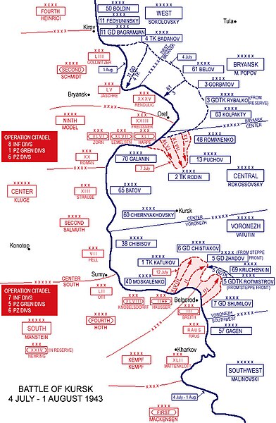
- Description: Battle of Kursk - 4 July-1 August 1943
- Source: www.westpoint.edu
- Background information:
In 1938 the predecessors of what is today The Department of History at the United States Military Academy began developing a series of campaign atlases to aid in teaching cadets a course entitled, "History of the Military Art." Since then, the Department has produced over six atlases and more than one thousand maps, encompassing not only America’s wars but global conflicts as well.
In keeping abreast with today's technology, the Department of History is providing these maps on the internet as part of the department's outreach program. The maps were created by the United States Military Academy’s Department of History and are the digital versions from the atlases printed by the United States Defense Printing Agency. We gratefully acknowledge the accomplishments of the department's former cartographer, Mr. Edward J. Krasnoborski, along with the works of our present cartographer, Mr. Frank Martini.
Šis paveikslėlis yra JAV Armijos kareivio ar darbuotojo darbas, sukurtas asmeniui einant oficialias pareigas. Kaip JAV federalinės valdžios sukurtas darbas, paveikslėlis yra laikomas viešo naudojimo.
|
 |
Rinkmenos istorija
Paspauskite ant datos/laiko, kad pamatytumėte rinkmeną tokią, kokia ji buvo tuo metu.
| Data/Laikas | Miniatiūra | Matmenys | Naudotojas | Paaiškinimas | |
|---|---|---|---|---|---|
| dabartinis | 11:59, 23 spalio 2008 | | 605 × 926 (279 KiB) | Noclador | {{Information |Description= |Source= |Date= |Author= |Permission= |other_versions= }} |
| 12:11, 23 vasario 2006 |  | 594 × 927 (160 KiB) | W.wolny |
Paveikslėlio naudojimas
Paveikslėlis yra naudojamas šiuose puslapiuose:
Visuotinis rinkmenos naudojimas
Ši rinkmena naudojama šiose viki svetainėse:
- Naudojama ar.wikipedia.org
- Naudojama azb.wikipedia.org
- Naudojama az.wikipedia.org
- Naudojama bg.wikipedia.org
- Naudojama bn.wikipedia.org
- Naudojama ca.wikipedia.org
- Naudojama ckb.wikipedia.org
- Naudojama cs.wikipedia.org
- Naudojama de.wikipedia.org
- Naudojama en.wikipedia.org
- Naudojama et.wikipedia.org
- Naudojama fi.wikipedia.org
- Naudojama fr.wikipedia.org
- Naudojama he.wikipedia.org
- Naudojama it.wikipedia.org
- Naudojama ja.wikipedia.org
- Naudojama ka.wikipedia.org
- Naudojama kk.wikipedia.org
- Naudojama ko.wikipedia.org
- Naudojama mn.wikipedia.org
- Naudojama ms.wikipedia.org
- Naudojama nl.wikipedia.org
Žiūrėti visuotinį šios rinkmenos naudojimą.
.jpg)
.jpg)